
Hurunui Hut No. 3 to Taramakau/Otehake Confluence.
25 K
What an amazing night’s sleep! The rain pattered and drummed on the roof last night, the wind gusted and blew, and even though the old building shook a little bit, it was cozy and warm and just plain easy.
A bit after 7:00 one of the Estonians gets up and lights the fire- everyone else takes this as a signal to get their breakfasts going. Down the long ladder to the floor, and I heat coffee and draw our favorite breakfast cereal, peanut butter chunky granola, out of the food bag. We are some of the last to leave that are leaving for the day, after hearing the fantastic story of the couple that is base camping out of this hut for the weekend- they met here as DoC workers 18 years ago, kissed on Arthurs Pass two weeks later, and are now on a trip celebrating their tenth anniversary. 
We step out the door into a world of partial blue skies and sun. Sun! The air is crisp and cool, and what a difference a little sunshine makes. 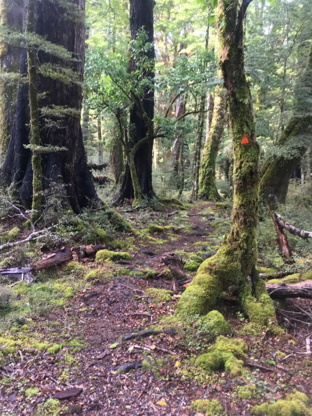
The ground is spongy and squishy and fully saturated, and my shoes are soaked immediately. Oh well. The forest has a lovely refreshed feel to it this morning. I find Prana at the first bridge of the day, a three wire, which is basically just one steel cable for your feet to balance on and two steel cables for your hands to balance on. It was like an element from a team building course, except over a mini river instead of over spotters. 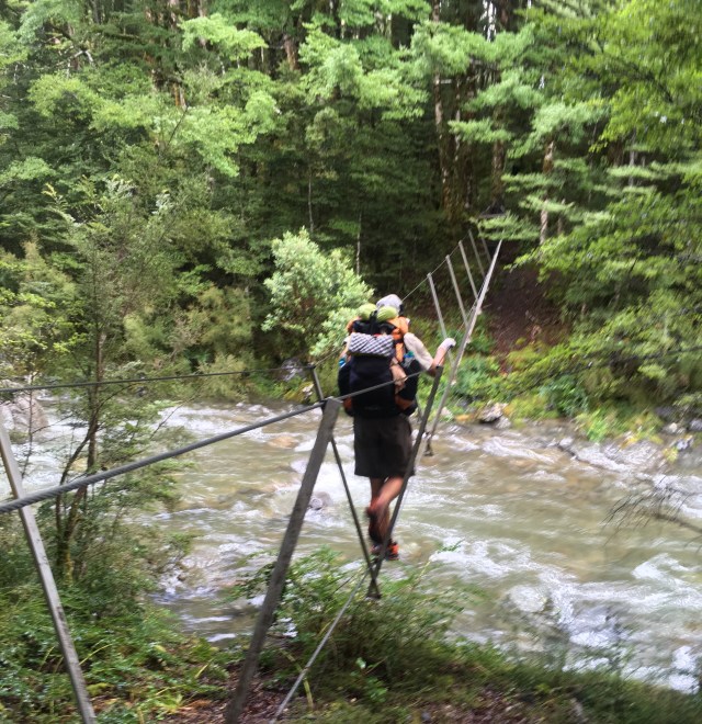
We crisscross quite a few streams, skirt several landslides, and climb down through a creek cascading over some blocky rocks that seem recently bared. Across an alluvial gravel field (or shingles, as gravel or cobbles are called over here) we reach Cameron Hut, a tiny old mini hut with cement walls and a dirt floor. Not the cutest, but I’m sure a welcome site in bad weather.
The forest is beautiful today, just beautiful! Is the forest that different, or is my mood inexplicably improved and transforming how I see things that would have bores me yesterday? I don’t know, so I just enjoy the enjoyment. Meta-enjoy.  It’s a long, fairly uneventful, fairly consistent, fairly scenic and fairly pleasant trudge up to the top of Harpers Pass. We pass Cameron Hut, a tired basic hut with a dirt floor, the Harper Pass Bivvy, a cute little two bunk hut painted the bright emergency orange (that I have ironically labeled in my mind as “happy cheerful orange”) and partially concealed in a riot of plant life.
The top of Harper Pass is pleasant enough; pretty, with promising larger mountain ranges in the distance. There is a chilly wind blowing over the pass, but we put on layers and sit down to eat lunch, firing up the stove to indulge in a hot midday mocha in an attempt to brighten the day. There had been a couple having lunch that we passed on the way up but I hadn’t talked to. Mario had, and now dutifully reported, “they said they had off trail hiking around the river crossing.” What does that even mean? It seems so vague in both description and placement, that I don’t give it much credit as a fair warning for anything.
It’s incredibly fascinating how one side of a pass can differ so much from the other, or how much can change between adjacent river valleys, and as we begin the descent of the south side of Harper Pass, I am pleased to find this side, the river valley of the Taramakau, much more engaging. 
Up here at the headwaters, there is lots of scrambling up and down and stepping in the sides of creek. Prana-the-sure-footed is often far ahead, and I call him McCloud for the rest of the day once he has spent his lead time using a rock to dig a track tread for the rest of us through a very fresh little landslide. Moss grows thick as luxury velvet draping the trees.
We navigate through a silty, gravelly, eroded section of the river. New side creeks erupt in full flow out of random spots in the rubbly banks; other side creeks with a long start disappear into the rubble before they reach the river itself. It feels like a primordial prototype testing ground for whatever force is designing the land.
Finally the concentration-demanding route-finding gives way to easy river meadow walking, through tall gardens of wild yellow flowers. The sun is out in full, so we stop for a break to eat snacks and wash our socks for the first time in far too long.
It’s less than a half a kilometer to the next hut, the Locke Stream, another 1940s triple bunk gem hand-built of hand-hewn timbers, the axe strokes visible. It is super cool. 
The main room has a fireplace and homemade dice on the table in front of it. I am impressed by this as much as the roof timbers.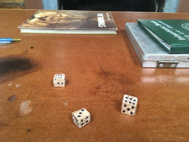
There is also an abandoned annotated TA map preaching a dire warning about the “tough as guts” section coming up. “4 hours for 4 k on the trail!” it exhorts. “Or take 1 hour to do 4 k on the road!” I despise that it is here, and consider removing it. What about adventure? What about discovery? What about the individual digging deep once they are committed to the unforeseen fray? Warnings like this, ones not for danger but simply for avoiding inconvenience or discomfort, take that away. Or at the very least taint the experience. Just my opinion.
We leave the hut, and have easy walking and small creek crossings. Occasionally the track darts into the trees and squeezes along the crumbling bank, then returns to the open ease of the meadow as the river swings away again. As we proceed downriver, this dart and squeeze move happens more and more frequently. One intriguing detail is this: the orange arrow markers are few and far between, and don’t even come close to matching the gps track on our maps, which is often on the opposite side of the river. Which is correct? I suppose it doesn’t matter, as long as we keep finding the next orange arrow. 
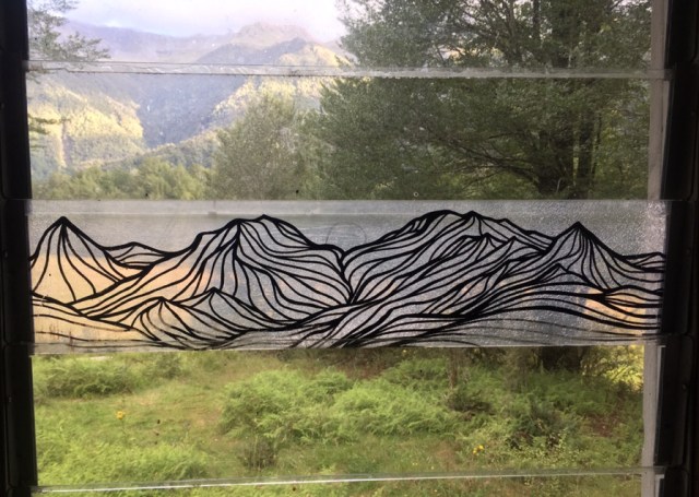
Eventually most of the river meadow is on our side of the river, and we reach Kiwi Hut- it has kind of an abandoned air that is not terribly inviting, although it does have a few endearing details. Inside is a beautiful etched glass panel depicting a mountain range, and on the hand-carved name plate there is an adorably lumpish kiwi with proportionately Moa-sized legs carved into sign.
Jay is staying here, as his shins and ankles are giving him trouble. We cook dinner while several curious gray robins hop around us, and then continue hiking into the beautiful evening light, hoping to complete the final river crossings and not have to think about any tomorrow.
Slanting rays of sun layer themselves through the thick mist surrounding the distant mountains. A huge waterfall churns inestimable amounts of water into a lacy spray, far up on a side wall. Mouse spies an orange arrow across the river, and it is commitment decision time- follow the arrows or follow the gps track? We decide to follow the arrows, which will lead us to cross the two main rivers separately, rather than the track that leads us to cross below the confluence when the forces are joined. We follow the arrow across the first braid of the Taramakau. 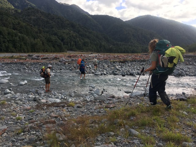
We cross a second braid, then a third. Now we seem to be out of luck, because there are no orange arrows to be found, and the next braid confronting us appears to not have an easy ford. We search until a cairn pops out of the background like an optical illusion, and it is indeed marking a simple crossing. One down, one to go. We cross the riverbed to the incoming Otehake. 
We cross a few ankle and knee deep channels, and are most of the way across. The evening light has started to deepen, and the last channel is, of course, the deepest. We hunt upstream, but the crossing ends in the vertical wall of a cutbank. We hunt downstream, but everything appears waist deep or deeper. Hmm. Prana and I drop our packs to test the mouth of the channel, where it may be shallow; it is up to our waist and flowing fast before we are a third of the way across. We return upstream to test a spot with a large eddy on the far side, but it is as deep even sooner. We start backtracking further, trying to ascertain if the far bank is scalable, and if so, how difficult bushwhacking would be. Prana finally tests a wide choppy spot in the channel without his pack, across from a plastic blue cup nailed up in a tree; it is just under waist deep on him, almost at
The half way point, and he reports he can see a trail leading into the forest. We could camp on this side, and see how much the water comes down over night with nothing lost; we decide we will give this one attempt and then camp if it doesn’t go. We all pull out our headlamps for the dark forest in case crossing is successful. Prana and I go in as a team to test it, and it turns out that just past halfway is the deepest point, up to over our waists, but then we are through, and getting shallower. Mario, Peach, and Mouse are right behind us, crossing in one group, and make it as well. 
Prana scrambles up the bank, and gives everyone else a helping haul up. 
Out of the river, I step forward to scout the trail. Except, there is no trail. “There is no trail.” I say. “There’s a trail,” Prana retorts. “It just…hasn’t been used in a long time.” I see there is no point to debate the finer points of my assertion, so I simply proceed in the direction we need to.
To be fair, I will say that there is occasionally a plastic cup nailed onto a tree that is in the most logical direction to push through the forest. I will say that the bushwhacking is not nearly as heinous as I assumed it would be. And I will say these facts still do not make it a trail. But, as Mouse optimistically observes, “this is really not even as bad as the real Trail is sometimes.” In 20 minutes, we are out of the forest, and onto the sand and cobble bank opposite of where our search to cross began. Time to camp!
We walk a short ways up the river until we reach a flat sandy area, then all pitch our tents. Time for dry fleece, time for chocolate, time to relax off of our feet. ‘Oh yeah,’ I think, as I make notes from the day before falling asleep, ‘off trail hiking around the river crossing. That’s what that couple was talking about.’

That bridge gives me anxiety. But those dice are awesome!
LikeLike