Upper Bush Stream Flats to Ski Field Road
22 k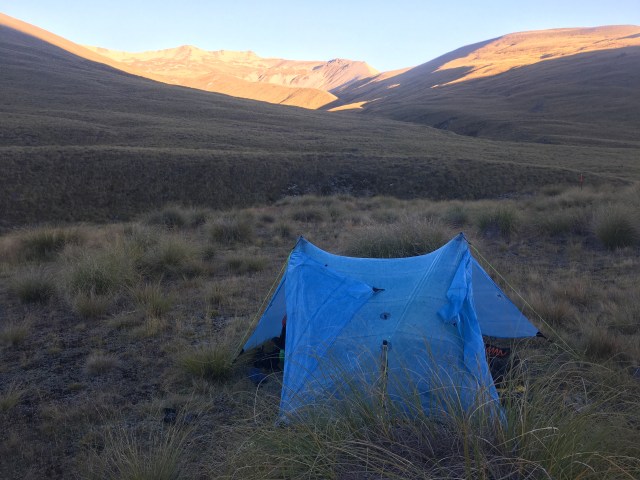
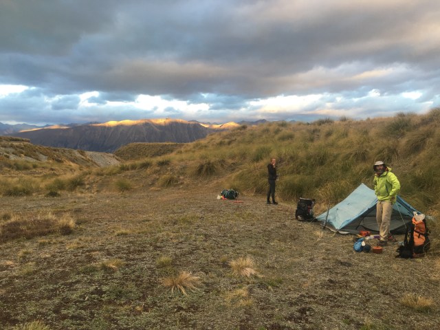
It was indeed a cold cold night. No light arrives until 6:15, we learn this morning, after trying to get up at our normal time, which is becoming too early. All layers are deployed and worn for warmth while we pack up and start hiking: fleeces, rain gear, gloves and waterproof sock covers.
We can see the hut straight away, just around the first curve- such is the power of the unknown. It was so close, and we never even sensed it. It probably would have been so much warmer in there! I am still pleased we camped, though; the tent feels like home on the trail.
Mouse and Laura are working on breakfast when we pop in to see their plan for the day. I go to use the long drop but choose the wrong path up the hill, and end up wandering past several metal implements that have large chunks of ice frozen in them. Not a skin of ice on a puddle of water- solid blocks of ice. I sigh in resignation to the knowledge that the first thing past the hut is several river crossings, of course. After finally locating the toilet from Prana’s flagging down below, we depart the hut.
We endure achingly cold feet for the first half hour, and then the sun comes out, which instantly causes a desperate delayering. Maybe it’s purely psychological, but the rover crossings in the sun seem far less painful than the ones in the early morning penumbra. As we walk, Mouse tells me the plot of a book she just finished reading, one full of twists and turns, family ancestors in cahoots, and Nazi spies.  Stag Saddle, the highest point on the TA, lies at the top of the morning’s climb. The path leads through and up a rocky streambed and across long piles of gravel scree. At several points water spurts out of the mountain side- it could be a spring, or it could be a water source from who knows where, running just below the talus. Either way it’s probably clean, and I lean over and drink straight from the mountain.
It’s hard to keep following the path through areas of the tussock, and Prana has a knack for finding it, or maybe for finding a path that works. I, however have no knack for it, or rather my knack is for choosing the worst possible dead end. I climb up frozen waves of golden land through three false summits, and then, there it is. The top! 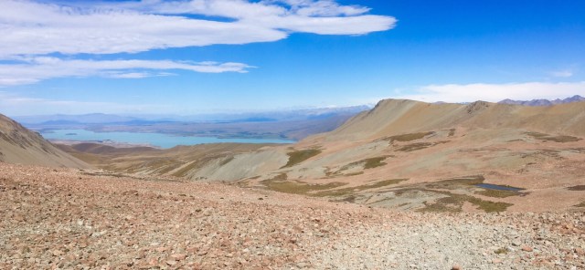 Someone has gone to a lot of work to build windbreak walls of the flat shale bricks. A sign announces the highest point of the TA, and Lake Tekapo, while not spectacular for any reason but the color, practically glows its opaque dazzling aquamarine down on the other side. We take several pictures, and, since we miss him, edit Bro into the summit shot. Duck family unite!
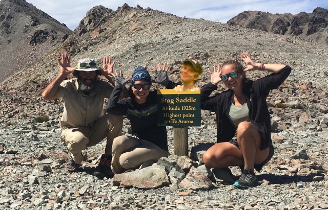 I check for phone service, and call around to book a hostel room for the incoming storm. Everything is booked but one bunk in a female dorm of the least recommended hostel, and one room in a very pricey hotel. Without much choice in the matter, we book these for the two nights they are available.
From here we can either drop down the drainage or take an alternate on the spine of the ridge until we have to abandon it for the drainage. Considering it is still fine weather for the moment, the alternate wins. We contour across and gain the ridge, and stunningly a massive, snow covered shield looms in the distance. Mt. Cook, I presume? I am gobsmacked, a sensation as if I am seeing the heart of this country for the first time.

We have fantastic views all the way down the ridge, and stop about a third of the way along for lunch so we can ooh and aah while we eat.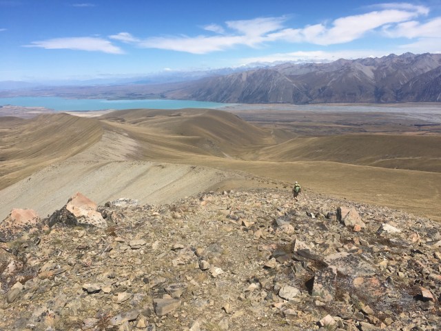
The tread on the spine is fantastic, and we make great time to where it drops back down to the valley, at which point it becomes a free-for-all of finding your way through the tussock. The wind picks up as we work our way down, a precursor of the supposed storm to be.
We finally intersect the track at the place where it becomes a road as it crosses the Coal River. The road winds around a bluff, and we reach the Camp Stream Hut, which is actually pretty cute. It’s tiny inside- a day laid over here would mean a day in the bunk, which actually doesn’t sound too bad. Antlers are the decor of choice inside and out, and split and chopped wood is stacked in huge metal culverts, a clever way to keep it dry. 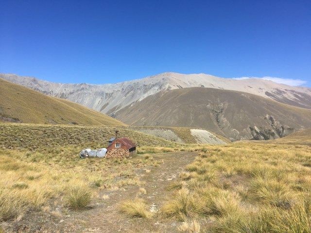
We are only doing ourselves a favor by making more distance tonight, so after a snack break we push on. The trail becomes ‘a bit wet underfoot’ as DoC brochures sometimes describe marshy bogs. It winds into and along the Camp Stream, pushed into the water several times due to slips and then eventually climbing straight up the cliff to gain the upper table land, into the wind. 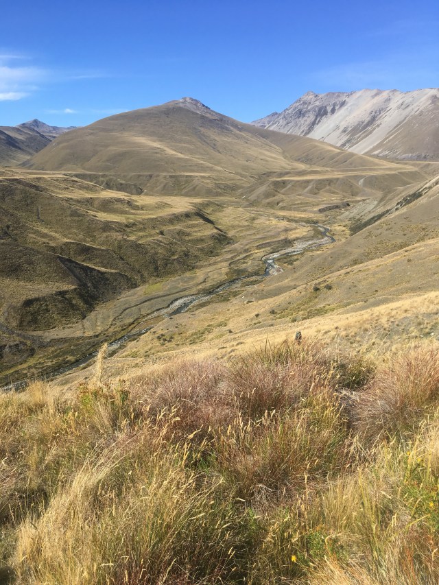
We find a semi-sheltered spot for dinner and are cooking the last dinner left in the foodbag when several hikers approach from the direction we are heading. The one in front looks vaguely familiar, but his soft voice is what gives him away- Mike, the Canadian guy we met in the first hut of the Tararuas. He is with two others, one who has beautiful intricate facial tattoos, and they are all hoping to cross the Rangitata before the storm tomorrow. We wish them somewhat dubious luck, and finish eating as I contemplate again our choice to go around the river and the slimness of our chances of finding a tentsite out of the wind tonight.
Not even an hour after dinner, walking across the flat high plain watching the tussock get whipped into frenzied whirligigs, we step down an embankment that marks a change in the trail from track to gravel road. Amazingly, inexplicably, right against the embankment is no wind. The guiding precept for tonight was the farther the better, but this seems too good of an opportunity to pass up. We decide to pitch our tents early, and accept the generous offering of the universe for a sheltered night.