
Start of Motatapu Track to Roses Hut
23 k (6500 feet elevation)
It isn’t raining when the alarm goes off, which is a huge motivation to actually get the day started; maybe the dry window will last long enough to get fully packed. The night was bizarrely warm, and after coffee and granola, we zip open the tent to a sky that is menacingly cloud-packed. It didn’t rain enough last night to actually reconstitute the cow poo, thank goodness, and we are able to pack things up dry and clean. 
We leave the campsite just ahead of Mouse, and when we reach the Fern Burn, it’s a lovely and steep little river with many small cascades, set within a sheer walled gorge. We follow along the bank for several hours, rising and descending as dictated by the rocky walls, gaining elevation overall. 
The mist has thickened into a gentle rain, but it is so warm it feels pleasant. We climb away from the stream until we are paralleling high above it, looking down into it. Then, up the valley, so inviting, the hut is visible.

We reach it while many are still preparing to leave for their days. The time it takes to have a quick snack and water is all it takes to get chilled in the damp air, our clothes soaked with sweat. Then we are off again.
The trail climbs and sidles, looking down on another falling creek and jagged rock formations sticking out everywhere. Above, on the same side of the drainage, rows of spike rock protrusions march upward in formation into the mist. 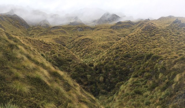
I reach Jack’s saddle, the high point for the day, and the view on the other side is stunning, a kaleidoscopic, geometric pattern of exposed rock where rivulets of water have worn the thin green cover away. 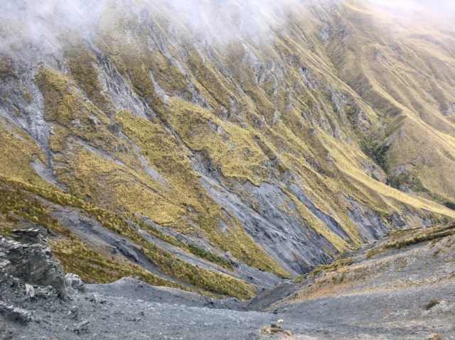
Our path follows a ridge arm down the other side, balancing perfectly on top of the slender apex. I look ahead into the valley, trying to figure out where the trail goes, but I can’t pinpoint it. Then the trail drops, plunging to the tiny stream at the base of the ridge before beelining straight back up the other side. Yeehaw. 
This ridge is spectacular as well, convoluted and corrugated in a way that when I spy Prana on a curve ahead, it looks like he shimmied up a sheer rock wall to get there. A few more steps reveal the delicate, undermined bridge of tussock that crosses a large land slide, accessing the next undulation. I am gobsmacked by this valley. 
A few more turns bring Highland Creek Hut into view well before the estimated time. It is set in a fabulous pocket of tussock with backdrop of rocky outcropping sand swirling clouds. This is where I would live. 
Sun orchids dot the tussocks, and the gentle descent gradually steepens to another quad buster. I can see the hut valley, though, and I realize we are going to smash the recommended time to this one as well. I pick my way on the steep and slippery bits, and indulge in gravity-assisted careening on the flatter smoother portions.
At the bottom, we wash some laundry in the stream, and I wish the weather report was better- I really could do one more climb today, the climb behind the hut, for an 8000 foot plus record elevation gain day; to make it on the High Score list. But gale force winds were predicted for tomorrow and this hut is the last on this section; if we have to wait tomorrow out I’d rather it not be in the flapping tent.
We approach the hut and see hiker detritus strewn all over the porch, and all manner of bits of cloth hanging from the rafters. It turns out to be mostly a group of girls from Sweden and the UK that we saw on and off around Arthur’s Pass, although I don’t get the impression they remember us. There are bunks open we can use, though, and that’s good enough for me, so we claim a couple on the top row.
Mouse arrives, and not long after, the other two girls that were in the last hut show up. Everyone cooks dinner in shifts, and settles in for the night. It’s pleasantly warm, and I doze off earlier than I want to in spite of myself, apparently worn out from the day’s hills.
